
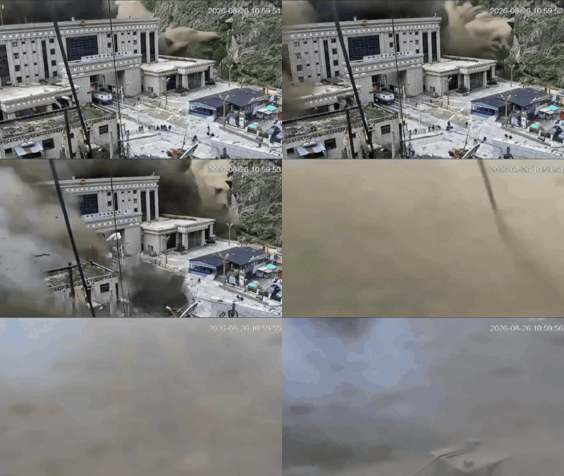
The glacier collapse that triggered a devastating landslide and flash floods along the Nepal-China border, killing over 1,100 showed visible signs of instability days before the disaster, according to a new report by the HiRISK scientific consortium.Scientists said there were “pre-event indications”, including meltwater that had turned visibly brown and signs of a crack propagating into the surrounding bedrock slope.The findings have raised fresh questions over the lack of operational early warning systems for glacier-related hazards in the remote Himalayan region, with scientists saying more comprehensive systems downstream could have saved a “significant number of lives”.
Warning signs before collapse?
The HiRISK report, published last week, cited by CNN, examined the physical changes preceding the glacier collapse and the potential for early detection.“In hindsight, there were some pre-event indications,” the scientists said, pointing to visibly brown meltwater and a crack that was propagating into the surrounding bedrock slope days before the collapse.However, detecting such changes in a remote, high-altitude environment remains difficult. The report said early warning systems had recently been established in the region to monitor several glacial lakes in China, but no operational system was in place specifically for glacier-related hazards in the area where the collapse occurred.Once the collapse began, the speed of the initial landslide meant conventional warning systems would likely have provided too little time to evacuate a border checkpoint that was among the first areas hit.Further downstream, however, there may have been more time to respond.The scientists said comprehensive early warning systems capable of providing 10 minutes or more of advance notice could have saved a “significant number of lives”.The finding stressed the need for systems that can monitor not only glacial lakes but also unstable glaciers and surrounding mountain slopes, while ensuring warnings reach vulnerable communities downstream.
Death toll rises to 1,127
As the cause and rescue ops continue, 1,127 people have died in the floods, according to Nepal Police. A total of 45 bodies have been recovered from Rasuwa, 155 from Nuwakot, 59 from Dhading, 348 from Chitwan, 66 from Gorkha, 38 from Tanahun, 217 from Nawalparasi East and 190 from Nawalparasi West.The death toll has risen to 1,127, with 45 bodies recovered in Rasuwa, 155 in Nuwakot, 59 in Dhading, 348 in Chitwan, 66 in Gorkha, 38 in Tanahun, 217 in Nawalparasi East and 190 in Nawalparasi West. Nine bodies have also been recovered in India. So far, only 95 of the total recovered bodies have been identified and handed over to their families.The disaster has also renewed calls for greater cooperation between Nepal and China in monitoring hazards across the Himalayas.Chinese and Nepali authorities had met as recently as May to discuss strengthening cooperation on monitoring natural hazards in the region, according to a government official who attended the meeting.Experts say better cross-border information sharing is particularly important because mountain hazards can rapidly affect communities and infrastructure on either side of the border.“There is almost no way that anyone could have detected this event prior – it happened in a blind spot … (making it) extremely difficult to detect,” Austin Lord, a senior fellow in the Energy, Water and Sustainability programme at the Stimson Center, wrote in a recent commentary.He also highlighted “how greater communication, information sharing, and collaborative analysis of transboundary risks between Nepal and China are sorely needed.”
Other reports also highlighted disaster possibility
The HiRISK report is separate from two major reports released by the International Centre for Integrated Mountain Development (ICIMOD) in March 2026.The ICIMOD reports examined longer-term changes across the Hindu Kush Himalaya and warned that accelerating glacier loss was increasing the risks of cryosphere-related hazards, including glacial lake outburst floods.They found that HKH glaciers lost around 12 per cent of their total area and 9 per cent of their estimated ice reserves between 1990 and 2020, while glacier ice loss had doubled after 2000.The reports also found that the region’s smallest glaciers were shrinking particularly rapidly, with three-fourths of HKH glaciers falling into the vulnerable category of less than 0.5 square kilometres.ICIMOD also highlighted major gaps in glacier monitoring. Its 2026 Glacier Outlook found that only seven of 38 monitored glaciers met the global benchmark monitoring standards set by the World Glacier Monitoring Service, while several major glacierised regions remained largely unmonitored.“This isn’t a distant problem; it’s a crisis unfolding in real-time, with new disasters every summer and monsoon,” ICIMOD Director General Pema Gyamtsho said.Thus, the ICIMOD reports provided a broad assessment of the region’s accelerating glacier loss and the risks it creates, while the new HiRISK report focuses specifically on the recent disaster, including the physical warning signs before the collapse and whether early warning systems could have reduced casualties.

Leave a Reply